
Southern Province topographic map
Interactive map
Click on the map to display elevation.
About this map
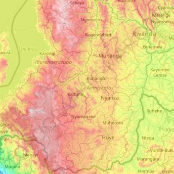
Name: Southern Province topographic map, elevation, terrain.
Location: Southern Province, Rwanda (-2.83976 29.27247 -1.73131 30.02081)
Average elevation: 1,729 m
Minimum elevation: 887 m
Maximum elevation: 2,938 m
Other topographic maps
Click on a map to view its topography, its elevation and its terrain.
Muhanga
Rwanda > Southern Province > Muhanga District
Muhanga, Muhanga District, Southern Province, Rwanda
Average elevation: 1,803 m
Kabacuzi
Rwanda > Southern Province > Muhanga District
Kabacuzi, Muhanga District, Southern Province, Rwanda
Average elevation: 1,734 m
Karama
Rwanda > Southern Province > Karama
Karama, Kamonyi, Southern Province, Rwanda
Average elevation: 1,625 m