
Strafford County topographic map
Interactive map
Click on the map to display elevation.
About this map
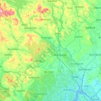
Name: Strafford County topographic map, elevation, terrain.
Location: Strafford County, New Hampshire, United States of America (43.08039 -71.24638 43.57301 -70.80952)
Average elevation: 148 m
Minimum elevation: -7 m
Maximum elevation: 719 m
Other topographic maps
Click on a map to view its topography, its elevation and its terrain.
Franconia
United States of America > New Hampshire > Franconia
Franconia, Grafton County, New Hampshire, 03580, United States of America
Average elevation: 351 m
Whitefield
United States of America > New Hampshire > Whitefield
Whitefield, Coös County, New Hampshire, United States of America
Average elevation: 366 m
Merrimack County
United States of America > New Hampshire
Merrimack County, New Hampshire, United States of America
Average elevation: 251 m
Grafton County
United States of America > New Hampshire
Grafton County, New Hampshire, United States of America
Average elevation: 424 m