
Mahakali topographic map
Interactive map
Click on the map to display elevation.
About this map
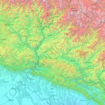
Name: Mahakali topographic map, elevation, terrain.
Location: Mahakali, Far-Western Development Region, Nepal (28.55070 80.05862 30.22721 81.10904)
Average elevation: 1,733 m
Minimum elevation: 151 m
Maximum elevation: 6,943 m
Other topographic maps
Click on a map to view its topography, its elevation and its terrain.
Nada
Nepal > Far-Western Development Region > Nada
Nada, Achham, Seti, Far-Western Development Region, Nepal
Average elevation: 1,199 m
Chandani
Nepal > Far-Western Development Region > Dodhara-Chandani
Chandani, Dodhara-Chandani, Kanchanpur, Mahakali, Far-Western Development Region, Nepal
Average elevation: 205 m
Far-Western Development Region
Nepal > Far-Western Development Region
Far-Western Development Region, Nepal
Average elevation: 1,652 m
Bhimdatta
Nepal > Far-Western Development Region > Bhimdatta
Bhimdatta, Kanchanpur, Mahakali, Far-Western Development Region, Nepal
Average elevation: 368 m
Kapkot
Nepal > Far-Western Development Region > Kanda
Kapkot, Kanda, Bajhang, Seti, Far-Western Development Region, Nepal
Average elevation: 5,133 m
Patan
Nepal > Far-Western Development Region > Patan
Patan, Baitadi, Mahakali, Far-Western Development Region, Nepal
Average elevation: 1,628 m
Sarda River
Nepal > Far-Western Development Region > Byas
Sarda River, Byas, Darchula, Mahakali, Far-Western Development Region, Nepal
Average elevation: 4,181 m
Chalsa
Nepal > Far-Western Development Region > Kamalbazar
Chalsa, Kamalbazar, Achham, Seti, Far-Western Development Region, Nepal
Average elevation: 1,147 m