
Vatican City topographic map
Interactive map
Click on the map to display elevation.
About this map
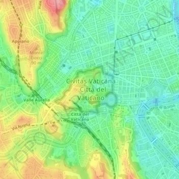
Name: Vatican City topographic map, elevation, terrain.
Location: Vatican City (41.90020 12.44579 41.90738 12.45837)
Average elevation: 47 m
Minimum elevation: 7 m
Maximum elevation: 114 m
Vatican City's climate is the same as Rome's: a temperate, Mediterranean climate Csa with mild, rainy winters from October to mid-May and hot, dry summers from May to September. Some minor local features, principally mists and dews, are caused by the anomalous bulk of St Peter's Basilica, the elevation, the fountains, and the size of the large paved square. The highest temperature ever recorded was 40.7 °C (105.3 °F), on both 2 August 2017 and 27 June 2022.
Other topographic maps
Click on a map to view its topography, its elevation and its terrain.
Montreal
Canada > Quebec > Urban agglomeration of Montreal > Montreal
Montreal, Urban agglomeration of Montreal, Montreal (06), Quebec, H3B 1M7, Canada
Average elevation: 30 m
Sri Lanka
Sri Lanka
Average elevation: 50 m
Hyderabad
India > Telangana > Bahadurpura mandal
Hyderabad, Bahadurpura mandal, Hyderabad District, Telangana, India
Average elevation: 549 m
India
India
Average elevation: 1,017 m
Thanjavur
India > Tamil Nadu > Thanjavur
Thanjavur, Thanjavur District, Tamil Nadu, 613001, India
Average elevation: 49 m
Pune
India > Maharashtra > Pune City > Pune
Pune, Pune City, Pune District, Maharashtra, 411001, India
Average elevation: 641 m
Tacoma
United States > Washington > Pierce County
Tacoma, Pierce County, Washington, United States
Average elevation: 67 m
Kanyakumari district
Kanyakumari district, Tamil Nadu, India
Average elevation: 226 m
Bengaluru
India > Karnataka > Bangalore North
Bengaluru, Bangalore North, Bengaluru Urban, Karnataka, India
Average elevation: 886 m
Snohomish County
Snohomish County, Washington, United States
Average elevation: 649 m
Chennai
India > Tamil Nadu > Chennai
Chennai, Chennai District, Tamil Nadu, India
Average elevation: 8 m
Surat
India > Gujarat > Katargam Taluka > Surat
Surat, Katargam Taluka, Surat, Gujarat, 395001, India
Average elevation: 11 m
Madurai
India > Tamil Nadu > Madurai
Madurai, Madurai South, Madurai district, Tamil Nadu, India
Average elevation: 138 m
Anaikatti
India > Tamil Nadu > Coimbatore North
Anaikatti, Mannarkad, Palakkad District, Kerala, 678741, India
Average elevation: 623 m
Stuvsta-Snättringe
Stuvsta-Snättringe, Huddinge kommun, Stockholm County, 141 43, Sweden
Average elevation: 41 m
Gladwyne
United States > Pennsylvania > Montgomery County > Lower Merion Township
Gladwyne, Lower Merion Township, Montgomery County, Pennsylvania, 19035, United States
Average elevation: 92 m
Nepal
Nepal
Average elevation: 2,604 m
Mandi
India > Himachal Pradesh > Mandi
Mandi, Mandi District, Himachal Pradesh, 175001, India
Average elevation: 1,273 m
Sector 62
India > Haryana > Gurugram District
Sector 62, Gurgaon, Gurugram District, Haryana, India
Average elevation: 235 m
Ammanapura Doddi
India > Karnataka > Ramanagara taluk
Ammanapura Doddi, Ramanagara taluk, Ramanagara District, Karnataka, 562138, India
Average elevation: 717 m
Bhatwari
Bhatwari, Uttarkashi District, Uttarakhand, India
Average elevation: 4,570 m
Musi River
Musi River, Hyderabad, Uppal mandal, Medchal–Malkajgiri, Telangana, 5000036, India
Average elevation: 490 m
Mangaluru
India > Karnataka > Mangaluru taluk
Mangaluru, Mangaluru taluk, Dakshina Kannada District, Karnataka, 575001, India
Average elevation: 25 m
Siliguri
India > West Bengal > Siliguri Subdivsion
Siliguri, Siliguri Subdivsion, Darjeeling District, West Bengal, India
Average elevation: 121 m
Vadodara
India > Gujarat > Vadodara Taluka
Vadodara, Vadodara Taluka, Vadodara District, Gujarat, 390001, India
Average elevation: 36 m
Dehradun
India > Uttarakhand > Dehradun
Dehradun, Dehradun District, Uttarakhand, 248001, India
Average elevation: 904 m
Ocheretyne
Ocheretyne, Ocheretyne settlement hromada, Pokrovskii Raion, Donetsk Oblast, 86020, Ukraine
Average elevation: 227 m
Blairingone
United Kingdom > Scotland > Perth and Kinross
Blairingone, Perth and Kinross, Scotland, FK14 7NU, United Kingdom
Average elevation: 93 m
Vitoria-Gasteiz
Spain > Autonomous Community of the Basque Country > Gasteizko kuadrilla/Cuadrilla de Vitoria
Vitoria-Gasteiz, Gasteizko kuadrilla/Cuadrilla de Vitoria, Álava, Autonomous Community of the Basque Country, Spain
Average elevation: 626 m
San Pedro de Quemes
Bolivia > Potosí > Provincia Nor Lípez > Municipio San Pedro de Quemes
San Pedro de Quemes, Canton San Pedro de Quemes, Municipio San Pedro de Quemes, Provincia Nor Lípez, Potosí, Bolivia
Average elevation: 3,710 m