
Thank you for supporting this site ❤️
Make a donation
Make a donation
Cumilla District topographic map
Click on the map to display elevation.
Thank you for supporting this site ❤️
Make a donation
Make a donation
About this map
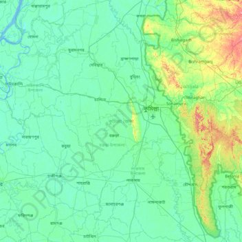
Name: Cumilla District topographic map, elevation, terrain.
Location: Cumilla District, Chattogram Division, Bangladesh (23.04474 90.63050 23.79659 91.37693)
Average elevation: 14 m
Minimum elevation: -2 m
Maximum elevation: 88 m
Thank you for supporting this site ❤️
Make a donation
Make a donation
Other topographic maps
Click on a map to view its topography, its elevation and its terrain.
Rangamati
Bangladesh > Chattogram Division > Rangamati Sadar Upazila
Rangamati (Bengali: রাঙ্গামাটি is the administrative headquarter and town of Rangamati District in the Chittagong Hill Tracts of Bangladesh. The town is located at 22°37'60N 92°12'0E and has an altitude of 14 metres (46 ft). It was the capital of the Chakma kingdom during the British rule…
Average elevation: 68 m
Thank you for supporting this site ❤️
Make a donation
Make a donation
Thank you for supporting this site ❤️
Make a donation
Make a donation
Thank you for supporting this site ❤️
Make a donation
Make a donation