Geolocate

Racine County topographic map

Interactive map

Click on the map to display elevation.

About this map

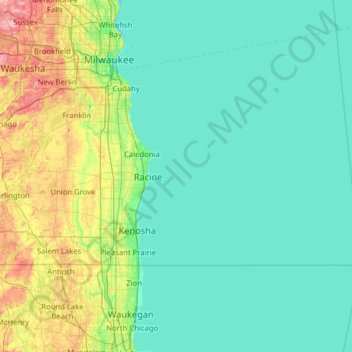
Name: Racine County topographic map, elevation, terrain.

Location: Racine County, Wisconsin, USA (42.61086 -88.30725 42.84566 -87.75560)

Average elevation: 228 m

Minimum elevation: 170 m

Maximum elevation: 310 m

Other topographic maps

Click on a map to view its topography, its elevation and its terrain.

City of Pewaukee

USA > Wisconsin > City of Pewaukee

City of Pewaukee, Waukesha County, Wisconsin, USA

Average elevation: 266 m

Racine

USA > Wisconsin > Racine

Racine, Racine County, Wisconsin, USA

Average elevation: 188 m

Lamartine

USA > Wisconsin > Lamartine

Lamartine, Fond du Lac County, Wisconsin, USA

Average elevation: 267 m

Fitchburg

USA > Wisconsin > Fitchburg

Fitchburg, Dane County, Wisconsin, USA

Average elevation: 299 m

Green Lake County

USA > Wisconsin

Green Lake County, Wisconsin, USA

Average elevation: 263 m

Navarino

USA > Wisconsin > Navarino

Navarino, Town of Navarino, Shawano County, Wisconsin, USA

Average elevation: 246 m