
Bandra topographic map
Interactive map
Click on the map to display elevation.
About this map
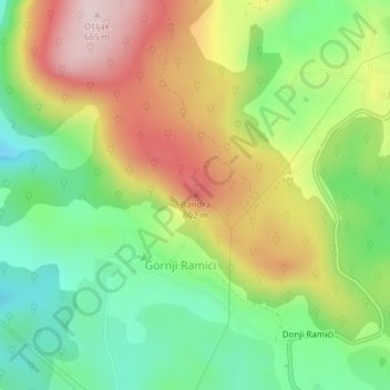
Name: Bandra topographic map, elevation, terrain.
Average elevation: 464 m
Minimum elevation: 312 m
Maximum elevation: 661 m
Other topographic maps
Click on a map to view its topography, its elevation and its terrain.
Galičica
B&H > Entity Federation of Bosnia and Herzegovina > Galičica
Galičica, Gornji Vakuf/Uskoplje municipality, Central Bosnia Canton, Entity Federation of Bosnia and Herzegovina, 70240, B&H
Average elevation: 796 m