
Sarajevo Canton topographic map
Interactive map
Click on the map to display elevation.
About this map
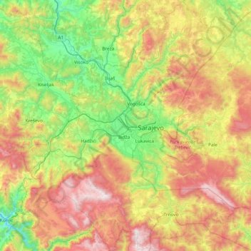
Name: Sarajevo Canton topographic map, elevation, terrain.
Location: Sarajevo Canton, B&H (43.58693 18.00096 44.12066 18.62962)
Average elevation: 957 m
Minimum elevation: 274 m
Maximum elevation: 2,065 m
Other topographic maps
Click on a map to view its topography, its elevation and its terrain.
Galičica
B&H > Entity Federation of Bosnia and Herzegovina > Galičica
Galičica, Gornji Vakuf/Uskoplje municipality, Central Bosnia Canton, Entity Federation of Bosnia and Herzegovina, 70240, B&H
Average elevation: 796 m
Bandra
B&H > Entity Federation of Bosnia and Herzegovina
Bandra, Ključ municipality, Una-Sana Canton, Entity Federation of Bosnia and Herzegovina, B&H
Average elevation: 464 m
Glavatičevo
Glavatičevo, Konjic municipality, Herzegovina-Neretva Canton, B&H
Average elevation: 594 m