
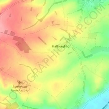
Halloughton topographic map
Interactive map
Click on the map to display elevation.
About this map
Name: Halloughton topographic map, elevation, terrain.
Average elevation: 64 m
Minimum elevation: 15 m
Maximum elevation: 104 m
Other topographic maps
Click on a map to view its topography, its elevation and its terrain.
Syerston
United Kingdom > England > Newark and Sherwood > Nottinghamshire
Syerston, Newark and Sherwood, Nottinghamshire, East Midlands, England, United Kingdom
Average elevation: 40 m
Fiskerton cum Morton
United Kingdom > England > Newark and Sherwood > Nottinghamshire
Fiskerton cum Morton, Newark and Sherwood, Nottinghamshire, East Midlands, England, United Kingdom
Average elevation: 21 m
Ollerton and Boughton CP
United Kingdom > England > Newark and Sherwood > Nottinghamshire
Ollerton and Boughton CP, Newark and Sherwood, Nottinghamshire, East Midlands, England, United Kingdom
Average elevation: 52 m
River Greet
United Kingdom > England > Newark and Sherwood > Nottinghamshire
River Greet, Newark and Sherwood, Nottinghamshire, East Midlands, England, NG25 0TT, United Kingdom
Average elevation: 15 m
Balderton
United Kingdom > England > Newark and Sherwood > Nottinghamshire
Balderton, Newark and Sherwood, Nottinghamshire, East Midlands, England, United Kingdom
Average elevation: 20 m