
Coventry topographic map
Interactive map
Click on the map to display elevation.
About this map
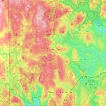
Name: Coventry topographic map, elevation, terrain.
Location: Coventry, Kent County, Rhode Island, United States (41.65605 -71.78970 41.73021 -71.53309)
Average elevation: 126 m
Minimum elevation: 47 m
Maximum elevation: 213 m
Other topographic maps
Click on a map to view its topography, its elevation and its terrain.
Warwick
United States > Rhode Island > Kent County
Warwick, Kent County, Rhode Island, United States
Average elevation: 16 m
West Warwick
United States > Rhode Island > Kent County
West Warwick, Kent County, Rhode Island, United States
Average elevation: 59 m
Masonic - Shriners Family Center
United States > Rhode Island > Kent County > Warwick
Masonic - Shriners Family Center, Warwick, Kent County, Rhode Island, United States
Average elevation: 7 m
West Warwick
United States > Rhode Island > Kent County
West Warwick, Kent County, Rhode Island, 02893, United States
Average elevation: 60 m
Hell's Half Acre
United States > Rhode Island > Kent County > West Greenwich
Hell's Half Acre, West Greenwich, Kent County, Rhode Island, 02822, United States
Average elevation: 110 m
Crompton
United States > Rhode Island > Kent County > West Warwick
Crompton, West Warwick, Kent County, Rhode Island, 02893, United States
Average elevation: 63 m
East Greenwich
United States > Rhode Island > Kent County
East Greenwich, Kent County, Rhode Island, 02818, United States
Average elevation: 21 m
Greene
United States > Rhode Island > Kent County > Coventry > Greene
Greene, Coventry, Kent County, Rhode Island, 02827, United States
Average elevation: 139 m
West Greenwich
United States > Rhode Island > Kent County
West Greenwich, Kent County, Rhode Island, 02817, United States
Average elevation: 111 m