
Northern Bruce Peninsula topographic map
Interactive map
Click on the map to display elevation.
About this map
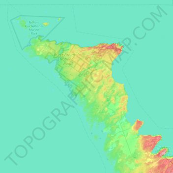
Name: Northern Bruce Peninsula topographic map, elevation, terrain.
Average elevation: 183 m
Minimum elevation: 170 m
Maximum elevation: 288 m
Other topographic maps
Click on a map to view its topography, its elevation and its terrain.
Fathom Five National Marine Park
Canada > Ontario > Northern Bruce Peninsula
Fathom Five National Marine Park, Elgin Street, Northern Bruce Peninsula, Bruce County, Ontario, N0H 2R0, Canada
Average elevation: 179 m