
Auxerre topographic map
Interactive map
Click on the map to display elevation.
About this map
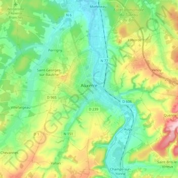
Name: Auxerre topographic map, elevation, terrain.
Average elevation: 156 m
Minimum elevation: 91 m
Maximum elevation: 291 m
La superficie de la commune est de 4 995 ha, dont une partie n'est pas construite ; son altitude varie entre 93 et 217 mètres.
Other topographic maps
Click on a map to view its topography, its elevation and its terrain.
Le Moulin de Billy
France > Bourgogne-Franche-Comté > Auxerre
Le Moulin de Billy, Auxerre, Yonne, Bourgogne-Franche-Comté, France métropolitaine, 89000, France
Average elevation: 170 m