
Bradford topographic map
Interactive map
Click on the map to display elevation.
About this map
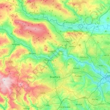
Name: Bradford topographic map, elevation, terrain.
Location: Bradford, Yorkshire and the Humber, England, United Kingdom (53.72434 -2.06125 53.96315 -1.64033)
Average elevation: 175 m
Minimum elevation: 28 m
Maximum elevation: 450 m
Other topographic maps
Click on a map to view its topography, its elevation and its terrain.
Ilkley
United Kingdom > England > Bradford
Ilkley, Bradford, West Yorkshire, England, United Kingdom
Average elevation: 221 m
Bingley
United Kingdom > England > Bradford
Bingley, Bradford, West Yorkshire, England, United Kingdom
Average elevation: 198 m