
Trafford topographic map
Interactive map
Click on the map to display elevation.
About this map
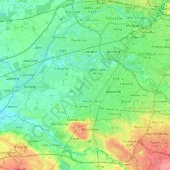
Name: Trafford topographic map, elevation, terrain.
Average elevation: 32 m
Minimum elevation: 8 m
Maximum elevation: 86 m
Other topographic maps
Click on a map to view its topography, its elevation and its terrain.
Partington
United Kingdom > England > Trafford > Partington
Partington, Trafford, Greater Manchester, England, United Kingdom
Average elevation: 19 m
Urmston
United Kingdom > England > Trafford
Urmston, Trafford, Greater Manchester, England, M41 9HD, United Kingdom
Average elevation: 24 m