
Staten Island topographic map
Interactive map
Click on the map to display elevation.
About this map
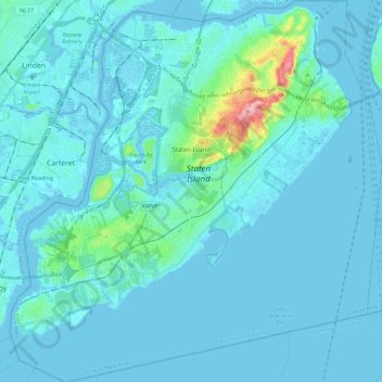
Name: Staten Island topographic map, elevation, terrain.
Location: Staten Island, New York, United States (40.49603 -74.25568 40.64889 -74.04925)
Average elevation: 11 m
Minimum elevation: -5 m
Maximum elevation: 122 m
Other topographic maps
Click on a map to view its topography, its elevation and its terrain.
Brooklyn
United States > New York > New York
Brooklyn, Kings County, New York, United States
Average elevation: 10 m
New York County
United States > New York > New York
New York County, New York, United States
Average elevation: 16 m