
Vilaflor topographic map
Interactive map
Click on the map to display elevation.
About this map
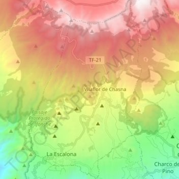
Name: Vilaflor topographic map, elevation, terrain.
Location: Vilaflor, Santa Cruz de Tenerife, Canary Islands, Spain (28.10432 -16.68941 28.21324 -16.61134)
Average elevation: 1,449 m
Minimum elevation: 341 m
Maximum elevation: 2,643 m
Other topographic maps
Click on a map to view its topography, its elevation and its terrain.
El Rosario
Spain > Canary Islands > Vilaflor
El Rosario, Vilaflor, Santa Cruz de Tenerife, Canary Islands, 38613, Spain
Average elevation: 2,045 m