
Oulgaret topographic map
Interactive map
Click on the map to display elevation.
About this map
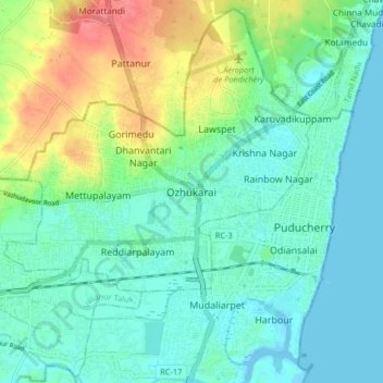
Name: Oulgaret topographic map, elevation, terrain.
Average elevation: 18 m
Minimum elevation: -5 m
Maximum elevation: 63 m
Other topographic maps
Click on a map to view its topography, its elevation and its terrain.
moolakulam
India > Puducherry > Ozhukarai Taluk > Oulgaret
moolakulam, Mettupalayam, Oulgaret, Ozhukarai Taluk, Puducherry district, Puducherry, 605010, India
Average elevation: 12 m
Kalapet
India > Puducherry > Ozhukarai Taluk
Kalapet, Ozhukarai Taluk, Puducherry District, Puducherry, 605014, India
Average elevation: 14 m