
Nagarjuna Sagar-Srisailam Tiger Reserve topographic map
Interactive map
Click on the map to display elevation.
About this map
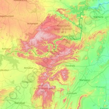
Name: Nagarjuna Sagar-Srisailam Tiger Reserve topographic map, elevation, terrain.
Location: Nagarjuna Sagar-Srisailam Tiger Reserve, Andhra Pradesh, India (15.39922 78.55019 16.67040 79.31271)
Average elevation: 340 m
Minimum elevation: 51 m
Maximum elevation: 956 m
Other topographic maps
Click on a map to view its topography, its elevation and its terrain.
Visakhapatnam
India > Andhra Pradesh > Visakhapatnam (Urban)
The city is situated between the Eastern Ghats and the Bay of Bengal. The city coordinates lies between 17.7041 N and 83.2977 E. The city's area is 682 km2. The average elevation is 45 metres. Visakhpatnam is situated in Coastal Andhra Region.
Average elevation: 35 m
Hindupur
India > Andhra Pradesh > Hindupur
Even in summers, the city experiences lower temperatures compared to the rest of the state due to its high elevation. Every Year, The lowest temperature will be around 3 degrees and highest temperature will be around 11 degrees. Average annual rainfall is 551mm.
Average elevation: 623 m
Vijayawada
Vijayawada lies on the banks of Krishna river, covered by hills and canals. and at an altitude of 11 m (36 ft) above sea level. Three canals originating from the north side of the Prakasam Barrage reservoir — Eluru, Bandar, and Ryves — flow through the city.
Average elevation: 37 m
Jammalamadugu
India > Andhra Pradesh > Jammalamadugu
Jammalamadugu is at 14°50′N 78°24′E / 14.83°N 78.4°E / 14.83; 78.4. It has an average elevation of 169 metres (554 feet).
Average elevation: 184 m
Rajampet
India > Andhra Pradesh > Rajampet
Rajampeta is a town in Annamayya district of the Indian state of Andhra Pradesh, located in the Rayalaseema Region formed on the banks of Cheyyeru River. The town has an average elevation of 139 meters (456 ft).
Average elevation: 147 m
Chittoor
The temperature in the western parts of the undivided district like Pileru, Punganur, Madanapalle, Horsley Hills are relatively lower than the eastern parts of the Chittoor District. This is because of the higher altitude of the western parts compared to the eastern parts. The summer temperature touches 44 °C…
Average elevation: 426 m
Anantapur
Penna, Chithravathi, Pedda Hagari, Chinna Hagari, Thadakaleru and Pandameru are the main rivers. The average elevation is about 1300 feet above the mean sea level. The annual normal rainfall of the district is 508.2 mm. Thus it secures least rainfall when compared to other parts of Andhra Pradesh.
Average elevation: 455 m
Kavali
India > Andhra Pradesh > Kavali
Kavali is located at 14°54′47″N 79°59′35″E / 14.913001°N 79.992921°E / 14.913001; 79.992921. It has an average elevation of 17 metres (56 ft). The town is at a distance of 8 km from the Bay of Bengal.
Average elevation: 15 m
Ahobilam
India > Andhra Pradesh > Allagadda
The pilgrimage site is divided into two main sections: Lower Ahobilam, where the principal village and the main temple complex are located, and Upper Ahobilam, approximately eight kilometers east, situated in a steep gorge hosting the revered Nava Narasimha temples — nine unique manifestations of Lord…
Average elevation: 269 m
Kurnool
India > Andhra Pradesh > Kurnool
Kurnool is located at 15°50′00″N 78°03′00″E / 15.8333°N 78.05°E / 15.8333; 78.05. It has an average elevation of 273 metres (898 feet). Kurnool lies on the banks of the Tungabhadra River. The Hundri and Neeva rivers also flow through the city. The K.C.Canal (Kurnool–Cuddapah) was built…
Average elevation: 307 m
Kadiri
India > Andhra Pradesh > Kadiri
Kadiri is located at 78.170 degrees E longitude and 14.120 degrees N latitude and has an average elevation of 504.00 meters (1653 feet) above MSL. Kadiri is surrounded by hill on the north and east.
Average elevation: 550 m
Tenali
India > Andhra Pradesh > Tenali
Tenali is situated at 16°14′20″N 80°38′42″E / 16.239°N 80.645°E / 16.239; 80.645, on the southern deltaic region of Krishna River. The city is spread over an area of 29.56 km2 (11.41 sq mi). It lies at an average altitude of 13 metres (43 ft) above mean sea level. It is also called as City…
Average elevation: 12 m
Ongole
India > Andhra Pradesh > Ongole
Ongole is located at 15.5°N 80.05°E. It has an average elevation of 10 m (33 ft) AMSL and is situated on the plains. The city is around 149 kilometres (93 mi) to the south west of Amaravati, the stat capital.
Average elevation: 15 m
Pakala
India > Andhra Pradesh > Pakala
Pakala consists of 180 villages and 28 panchayats. Nagamma Agraharam is the smallest village and Pakala is the biggest village. It is in the 371 m elevation (altitude).
Average elevation: 384 m
Pakala
India > Andhra Pradesh > Pakala
Pakala consists of 180 villages and 28 panchayats. Nagamma Agraharam is the smallest village and Pakala is the biggest village. It is in the 371 m elevation (altitude).
Average elevation: 384 m
Ongole
India > Andhra Pradesh > Ongole
Ongole is located at 15.5°N 80.05°E. It has an average elevation of 10 m (33 ft) AMSL and is situated on the plains. The city is around 149 kilometres (93 mi) to the south west of Amaravati, the stat capital.
Average elevation: 15 m
Jammalamadugu
India > Andhra Pradesh > Jammalamadugu
Jammalamadugu is at 14°50′N 78°24′E / 14.83°N 78.4°E / 14.83; 78.4. It has an average elevation of 169 metres (554 feet).
Average elevation: 184 m
Madakasira
India > Andhra Pradesh > Madakasira
Madakasira is located at 13°56′13″N 77°16′10″E / 13.9369°N 77.2694°E / 13.9369; 77.2694. It has an average elevation of 676 metres (2221 ft). The height of the Madakasira hill is 2936 feet from the Sea Level.Formerly Madakasira is called as SIMHAGIRI because hill from one side looks like a…
Average elevation: 684 m
Madanapalle
India > Andhra Pradesh > Madanapalle
It is located at an average elevation of 695 m (2,280 ft) above mean sea level.
Average elevation: 766 m
Kakinada
India > Andhra Pradesh > Kakinada (Urban)
Kakinada is located at 16°56′N 82°13′E / 16.93°N 82.22°E / 16.93; 82.22. The 82-degrees east longitude passes through the city. It has an average elevation of 2 metres (6 ft), and many areas of the city are below sea level.
Average elevation: 7 m