
Kandana topographic map
Interactive map
Click on the map to display elevation.
About this map
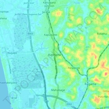
Name: Kandana topographic map, elevation, terrain.
Location: Kandana, Gampaha District, Western Province, 11350, Sri Lanka (7.00785 79.85706 7.08785 79.93706)
Average elevation: 11 m
Minimum elevation: -1 m
Maximum elevation: 51 m
Other topographic maps
Click on a map to view its topography, its elevation and its terrain.
Rilaulla Junction
Sri Lanka > Western Province > Kandana > Rilaulla Junction
Rilaulla Junction, Kandana, Gampaha District, Western Province, 11350, Sri Lanka
Average elevation: 12 m