
Bamori topographic map
Interactive map
Click on the map to display elevation.
About this map
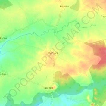
Name: Bamori topographic map, elevation, terrain.
Location: Bamori, Bamori Tahsil, Guna, Madhya Pradesh, India (24.81262 77.09913 24.89262 77.17913)
Average elevation: 438 m
Minimum elevation: 410 m
Maximum elevation: 470 m
Other topographic maps
Click on a map to view its topography, its elevation and its terrain.
Ratnagir
India > Madhya Pradesh > Bamori Tahsil
Ratnagir, Bamori Tahsil, Guna District, Madhya Pradesh, India
Average elevation: 394 m
Paroda
India > Madhya Pradesh > Bamori Tahsil
Paroda, Bamori Tahsil, Guna District, Madhya Pradesh, India
Average elevation: 414 m