
Cranham topographic map
Interactive map
Click on the map to display elevation.
About this map
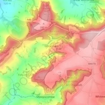
Name: Cranham topographic map, elevation, terrain.
Location: Cranham, Stroud, Gloucestershire, England, United Kingdom (51.79672 -2.18097 51.82456 -2.11007)
Average elevation: 196 m
Minimum elevation: 65 m
Maximum elevation: 295 m
Other topographic maps
Click on a map to view its topography, its elevation and its terrain.
Little Haresfield
United Kingdom > England > Gloucestershire > Stroud > Standish
Average elevation: 43 m
River Frome
United Kingdom > England > Gloucestershire > Stroud > Chalford > Chalford Hill
Average elevation: 163 m
Jubilee Playing Field & Athletics Track
United Kingdom > England > Gloucestershire > Stroud > Cam > Draycott
Average elevation: 45 m
Far Oakridge
United Kingdom > England > Gloucestershire > Stroud > Oakridge Lynch
Average elevation: 180 m
Draycott
United Kingdom > England > Gloucestershire > Stroud > Gossington > Draycott
Average elevation: 43 m