
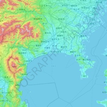
Kanagawa Prefecture topographic map
Interactive map
Click on the map to display elevation.
About this map
Name: Kanagawa Prefecture topographic map, elevation, terrain.
Location: Kanagawa Prefecture, Japan (34.95717 138.91577 35.67290 139.85775)
Average elevation: 170 m
Minimum elevation: -4 m
Maximum elevation: 1,639 m
Topographically, the prefecture consists of three distinct areas. The mountainous western region features the Tanzawa Mountain Range and Hakone Volcano. The hilly eastern region is characterized by the Tama Hills and Miura Peninsula. The central region, which surrounds the Tama Hills and Miura Peninsula, consists of flat stream terraces and low lands around major rivers including the Sagami River, Sakai River, Tsurumi River, and Tama River.
Other topographic maps
Click on a map to view its topography, its elevation and its terrain.
Motoyama
Motoyama, Nagaoka County, Kochi Prefecture, 781-3601, Japan
Average elevation: 679 m
Niki
Niki, Yoichi County, Shiribeshi Subprefecture, Hokkaido Prefecture, Japan
Average elevation: 269 m
Kusatsu
Kusatsu, Agatsuma County, Gunma Prefecture, Japan
Average elevation: 1,171 m
Kansai Region
Japan > Chubu Region > Nagoya
Kansai Region, Joto, Osaka Prefecture, Japan
Average elevation: 194 m
Nidan Fall
Nidan Fall, Matsumoto, Nagano Prefecture, Japan
Average elevation: 2,048 m
Jodogahama Observation Spot
Jodogahama Observation Spot, 浄土ヶ浜自然歩道, 鍬ヶ崎, Miyako, Iwate Prefecture, 027-0076, Japan
Average elevation: 22 m
Tsuwano
Tsuwano, Kanoashi County, Shimane Prefecture, Japan
Average elevation: 330 m