
Marakanam topographic map
Interactive map
Click on the map to display elevation.
About this map
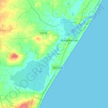
Name: Marakanam topographic map, elevation, terrain.
Location: Marakanam, Viluppuram District, Tamil Nadu, India (12.04181 79.72366 12.27992 80.00754)
Average elevation: 9 m
Minimum elevation: -2 m
Maximum elevation: 56 m
Other topographic maps
Click on a map to view its topography, its elevation and its terrain.
Murukkeri
India > Tamil Nadu > Marakanam > Murukkeri
Murukkeri, Marakanam, Viluppuram District, Tamil Nadu, 604301, India
Average elevation: 21 m