
Yalahanka topographic map
Interactive map
Click on the map to display elevation.
About this map
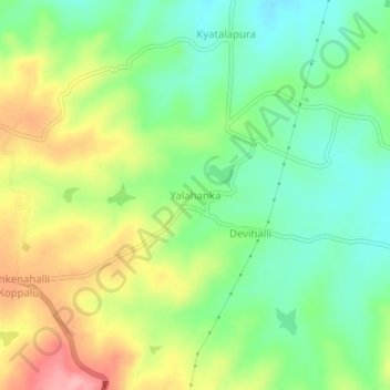
Name: Yalahanka topographic map, elevation, terrain.
Average elevation: 959 m
Minimum elevation: 908 m
Maximum elevation: 1,034 m
Other topographic maps
Click on a map to view its topography, its elevation and its terrain.
Shettigere
India > Karnataka > Beluru taluk
Shettigere, Beluru taluk, Hassan District, Karnataka, India
Average elevation: 972 m