
Thank you for supporting this site ❤️
Make a donation
Make a donation
Harihareshwar topographic map
Click on the map to display elevation.
Thank you for supporting this site ❤️
Make a donation
Make a donation
About this map
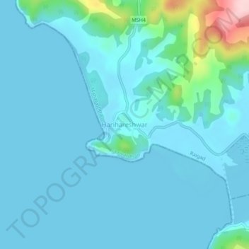
Name: Harihareshwar topographic map, elevation, terrain.
Location: Harihareshwar, Shrivardhan, Raigad, Maharashtra, India (17.97509 73.00453 18.01509 73.04453)
Average elevation: 26 m
Minimum elevation: -1 m
Maximum elevation: 240 m
Thank you for supporting this site ❤️
Make a donation
Make a donation