
Tours topographic map
Interactive map
Click on the map to display elevation.
About this map
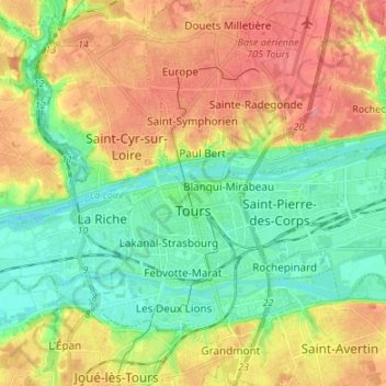
Name: Tours topographic map, elevation, terrain.
Average elevation: 73 m
Minimum elevation: 40 m
Maximum elevation: 116 m
Other topographic maps
Click on a map to view its topography, its elevation and its terrain.
Azay-le-Rideau
France > Centre-Val de Loire > Indre-et-Loire
Azay-le-Rideau, Tours, Indre-et-Loire, Centre-Val de Loire, Metropolitan France, 37190, France
Average elevation: 79 m
Sonzay
France > Centre-Val de Loire > Indre-et-Loire
Sonzay, Chinon, Indre-et-Loire, Centre-Val de Loire, Metropolitan France, 37360, France
Average elevation: 113 m