
Missouri River topographic map
Interactive map
Click on the map to display elevation.
About this map
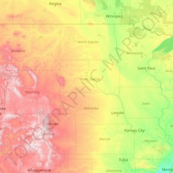
Name: Missouri River topographic map, elevation, terrain.
Location: Missouri River, Sully County, South Dakota, 64072, USA (38.53487 -112.01534 48.14971 -90.11771)
Average elevation: 901 m
Minimum elevation: 60 m
Maximum elevation: 4,096 m
Other topographic maps
Click on a map to view its topography, its elevation and its terrain.
Pine Ridge
USA > South Dakota > Pine Ridge
Pine Ridge, Oglala Lakota County, South Dakota, USA
Average elevation: 997 m
Mount McKinley
Mount McKinley, Harding County, South Dakota, USA
Average elevation: 980 m