
Gustavo A. Madero topographic map
Interactive map
Click on the map to display elevation.
About this map
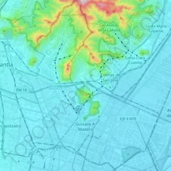
Name: Gustavo A. Madero topographic map, elevation, terrain.
Location: Gustavo A. Madero, Mexico City, Mexico (19.44479 -99.17705 19.59276 -99.05087)
Average elevation: 2,301 m
Minimum elevation: 2,223 m
Maximum elevation: 2,992 m
Other topographic maps
Click on a map to view its topography, its elevation and its terrain.
Volcán Chichinautzin
Volcán Chichinautzin, Mexico City, 14904, Mexico
Average elevation: 3,240 m