
Ardennes topographic map
Interactive map
Click on the map to display elevation.
Ardennes
Covering 5,229 square kilometres (2,019 square miles), the department was the smallest among the four contributors to Champagne-Ardenne. It is diverse in climate, topography, natural vegetation and land use, which is a mixture of forest and arable farming.
About this map
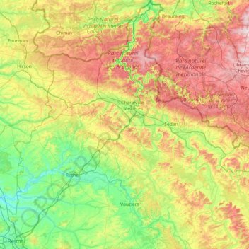
Name: Ardennes topographic map, elevation, terrain.
Location: Ardennes, Grand Est, Metropolitan France, France (49.22685 4.02460 50.16932 5.39407)
Average elevation: 225 m
Minimum elevation: 55 m
Maximum elevation: 574 m
Other topographic maps
Click on a map to view its topography, its elevation and its terrain.