
Thank you for supporting this site ❤️
Make a donation
Make a donation
Ardennes topographic map
Click on the map to display elevation.
Thank you for supporting this site ❤️
Make a donation
Make a donation
Ardennes
Covering 5,229 square kilometres (2,019 square miles), the department was the smallest among the four contributors to Champagne-Ardenne. It is diverse in climate, topography, natural vegetation and land use, which is a mixture of forest and arable farming.
Thank you for supporting this site ❤️
Make a donation
Make a donation
About this map
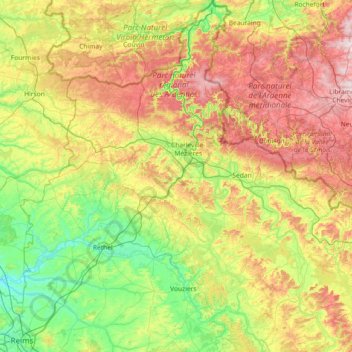
Name: Ardennes topographic map, elevation, terrain.
Location: Ardennes, Grand Est, Metropolitan France, France (49.22685 4.02460 50.16932 5.39407)
Average elevation: 225 m
Minimum elevation: 55 m
Maximum elevation: 574 m
Thank you for supporting this site ❤️
Make a donation
Make a donation
Other topographic maps
Click on a map to view its topography, its elevation and its terrain.