
Ambasamudram topographic map
Interactive map
Click on the map to display elevation.
About this map
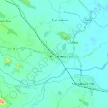
Name: Ambasamudram topographic map, elevation, terrain.
Location: Ambasamudram, Tirunelveli District, Tamil Nadu, 627400, India (8.66554 77.40201 8.74554 77.48201)
Average elevation: 73 m
Minimum elevation: 51 m
Maximum elevation: 213 m
Maancholai Hills is located between elevations ranging from 1,000 to 1,500 Metres, the Maancholai area is set deep within the Western Ghats within the Kalakad Mundanthurai Tiger Reserve in the Tirunelveli District. Located on top of the Manimuthar Dam & the Manimuthar Water Falls, the Maancholai area comprises Tea Plantations, Small settlements around the tea plantations; Upper Kodaiyar Dam and a windy view point called Kuthiravetti. Manimuttar Dam, Gadananathi River Dam, Rice Research Station of TNAU, Papanasam Dam, Karaiyar Dam, Singampatti Zamin palace, Servalar Dam, Kalakkad Mundanthurai Tiger Reserve, Agasthiyar Falls fed by lower dam., Baana Theertham Falls, Tamirabarani river, Sri Vedhanarayanar Rajagopalaswami Kulasekhara Azhwar Temple, Papanasaswamy Temple, Agashtiyar Temple, Krishnaswamy temple, kasi viswanathar temple and Durgai Amman Temple are the common visitor attractions around the town.