
Sherbro Island topographic map
Interactive map
Click on the map to display elevation.
About this map
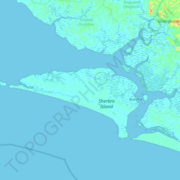
Name: Sherbro Island topographic map, elevation, terrain.
Average elevation: 3 m
Minimum elevation: -4 m
Maximum elevation: 187 m
Other topographic maps
Click on a map to view its topography, its elevation and its terrain.
Selu
Sierra Leone > Southern Province > Selu
Selu, Bo District, Southern Province, Sierra Leone
Average elevation: 237 m
Bonthe
Sierra Leone > Southern Province > Bonthe
Bonthe, Bonthe District, Southern Province, Sierra Leone
Average elevation: 2 m
Sewa
Sierra Leone > Southern Province
Sewa, Bo District, Southern Province, Sierra Leone
Average elevation: 149 m