
South Yorkshire topographic map
Interactive map
Click on the map to display elevation.
About this map
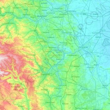
Name: South Yorkshire topographic map, elevation, terrain.
Average elevation: 123 m
Minimum elevation: 0 m
Maximum elevation: 630 m
Other topographic maps
Click on a map to view its topography, its elevation and its terrain.
Rotherham
United Kingdom > England > Rotherham
Rotherham, Yorkshire and the Humber, England, United Kingdom
Average elevation: 101 m