
Hilo topographic map
Interactive map
Click on the map to display elevation.
About this map
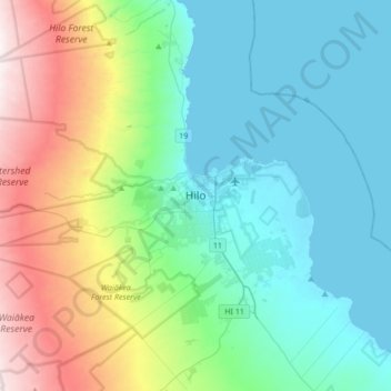
Name: Hilo topographic map, elevation, terrain.
Average elevation: 313 m
Minimum elevation: 0 m
Maximum elevation: 1,254 m
Hilo has a tropical rainforest climate (Köppen Af), with substantial rainfall throughout the year. Its location on the windward coast (relative to the trade winds), makes it the fourth-wettest city in the United States, behind the southeast Alaskan cities of Whittier, Ketchikan and Yakutat, and one of the wettest in the world. An average of around 126.72 inches (3,220 mm) of rain fell at Hilo International Airport annually between 1981 and 2010, with 272 days of the year receiving some rain. Rainfall in Hilo varies with altitude, with more at higher elevations. At some weather stations in upper Hilo the annual rainfall is above 200 inches (5,100 mm).
Other topographic maps
Click on a map to view its topography, its elevation and its terrain.
Mauna Kea
United States of America > Hawaii > Hilo
Mauna Kea, Hilo, Hawaiʻi County, Hawaii, United States of America
Average elevation: 3,979 m