
San Miguel Zinacantepec topographic map
Interactive map
Click on the map to display elevation.
About this map
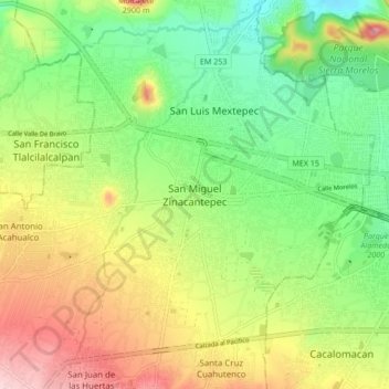
Name: San Miguel Zinacantepec topographic map, elevation, terrain.
Location: San Miguel Zinacantepec, Zinacantepec, 51354, México (19.24449 -99.77504 19.32449 -99.69504)
Average elevation: 2,757 m
Minimum elevation: 2,663 m
Maximum elevation: 2,891 m
Other topographic maps
Click on a map to view its topography, its elevation and its terrain.
Santa Cruz Cuahutenco
Santa Cruz Cuahutenco, Zinacantepec, 51367, México
Average elevation: 2,820 m
San Luis Mextepec
San Luis Mextepec, Zinacantepec, 51355, México
Average elevation: 2,736 m