
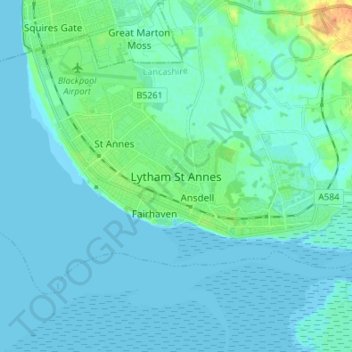
Lytham St Annes topographic map
Interactive map
Click on the map to display elevation.
About this map
Name: Lytham St Annes topographic map, elevation, terrain.
Average elevation: 5 m
Minimum elevation: -1 m
Maximum elevation: 31 m
Other topographic maps
Click on a map to view its topography, its elevation and its terrain.
Warton Bank
United Kingdom > England > Lancashire > Borough of Fylde > Warton
Warton Bank, Bryning-with-Warton, Warton, Borough of Fylde, Lancashire, England, PR4 1TB, United Kingdom
Average elevation: 8 m
Freckleton
United Kingdom > England > Lancashire > Borough of Fylde
Freckleton, Borough of Fylde, Lancashire, England, United Kingdom
Average elevation: 12 m
Thistleton
United Kingdom > England > Lancashire > Borough of Fylde
Thistleton, Greenhalgh-with-Thistleton, Borough of Fylde, Lancashire, England, PR4 3XA, United Kingdom
Average elevation: 17 m
Weeton
United Kingdom > England > Lancashire > Borough of Fylde
Weeton, Borough of Fylde, Lancashire, England, PR4 3PB, United Kingdom
Average elevation: 22 m
Kirkham
United Kingdom > England > Lancashire > Borough of Fylde
Kirkham, Borough of Fylde, Lancashire, England, United Kingdom
Average elevation: 22 m
Staining
United Kingdom > England > Lancashire > Borough of Fylde
Staining, Borough of Fylde, Lancashire, England, FY3 0BS, United Kingdom
Average elevation: 14 m