
Bhiwadi topographic map
Interactive map
Click on the map to display elevation.
About this map
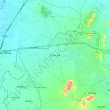
Name: Bhiwadi topographic map, elevation, terrain.
Average elevation: 258 m
Minimum elevation: 187 m
Maximum elevation: 406 m
Other topographic maps
Click on a map to view its topography, its elevation and its terrain.
Rambas
India > Rajasthan > Tijara Tehsil > Shekhpur Aheer
Rambas, Shekhpur Aheer, Tijara Tehsil, Kherthal-Tijara District, Rajasthan, 301411, India
Average elevation: 287 m
Shahbad
India > Rajasthan > Tijara Tehsil > Shahbad
Shahbad, Tijara Tehsil, Alwar, Rajasthan, 301411, India
Average elevation: 282 m