
Barghat Tahsil topographic map
Interactive map
Click on the map to display elevation.
About this map
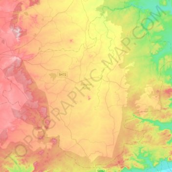
Name: Barghat Tahsil topographic map, elevation, terrain.
Location: Barghat Tahsil, Seoni, Madhya Pradesh, India (21.85487 79.57197 22.19015 79.95233)
Average elevation: 529 m
Minimum elevation: 328 m
Maximum elevation: 728 m
Other topographic maps
Click on a map to view its topography, its elevation and its terrain.
Birholi
India > Madhya Pradesh > Barghat Tahsil
Birholi, Barghat Tahsil, Seoni District, Madhya Pradesh, India
Average elevation: 546 m
Barghat
India > Madhya Pradesh > Barghat Tahsil
Barghat, Barghat Tahsil, Seoni District, Madhya Pradesh, 480667, India
Average elevation: 534 m