
Thank you for supporting this site ❤️
Make a donation
Make a donation
Vientiane Capital topographic map
Click on the map to display elevation.
Thank you for supporting this site ❤️
Make a donation
Make a donation
About this map
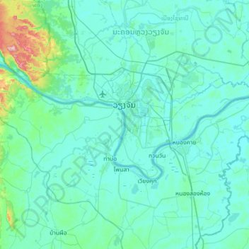
Name: Vientiane Capital topographic map, elevation, terrain.
Average elevation: 187 m
Minimum elevation: 156 m
Maximum elevation: 531 m
Thank you for supporting this site ❤️
Make a donation
Make a donation
Other topographic maps
Click on a map to view its topography, its elevation and its terrain.
B. Phonsavang
Laos > Vientiane Prefecture > Chanthabuly District > Vientiane Capital
Average elevation: 174 m
B. Phonthongchommani
Laos > Vientiane Prefecture > Chanthabuly District > Vientiane Capital
Average elevation: 173 m
Hatsadi
Laos > Vientiane Prefecture > Chanthabuly District > Vientiane Capital
Average elevation: 170 m