
Kodaikanal Solar Observatory topographic map
Interactive map
Click on the map to display elevation.
About this map
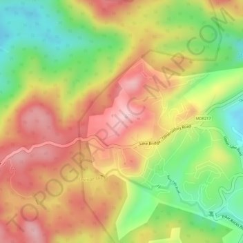
Name: Kodaikanal Solar Observatory topographic map, elevation, terrain.
Average elevation: 2,238 m
Minimum elevation: 2,111 m
Maximum elevation: 2,337 m
Other topographic maps
Click on a map to view its topography, its elevation and its terrain.
Kodaikanal
India > Tamil Nadu > Kodaikanal > Kodaikanal
Kodaikanal, Dindigul District, Tamil Nadu, 624100, India
Average elevation: 1,763 m
Silver Cascade Falls
India > Tamil Nadu > Kodaikanal > Kodaikanal
Silver Cascade Falls, Kodaikanal, Dindigul District, Tamil Nadu, 624100, India
Average elevation: 1,890 m