
Thank you for supporting this site ❤️
Make a donation
Make a donation
Murtijapur topographic map
Click on the map to display elevation.
Thank you for supporting this site ❤️
Make a donation
Make a donation
Murtijapur
Murtizapur is located at an average elevation of 308 metres (1210 feet). It is an important railway junction station in Akola district and is under Bhusawal-Badnera Section of Bhusawal Division of Central Railway.
Thank you for supporting this site ❤️
Make a donation
Make a donation
About this map
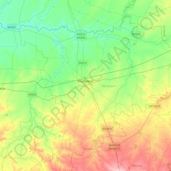
Name: Murtijapur topographic map, elevation, terrain.
Location: Murtijapur, Akola, Maharashtra, 444106, India (20.56763 77.21142 20.88011 77.61940)
Average elevation: 308 m
Minimum elevation: 252 m
Maximum elevation: 414 m
Thank you for supporting this site ❤️
Make a donation
Make a donation