Geolocate

Mandiram topographic map

Interactive map

Click on the map to display elevation.

About this map

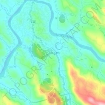
Name: Mandiram topographic map, elevation, terrain.

Location: Mandiram, Ranni, Pathanamthitta District, Kerala, 689672, India (9.34008 76.76715 9.38008 76.80715)

Average elevation: 51 m

Minimum elevation: -2 m

Maximum elevation: 195 m

Other topographic maps

Click on a map to view its topography, its elevation and its terrain.

Chethonkara

India > Kerala > Ranni

Chethonkara, Ranni, Pathanamthitta District, Kerala, 689675, India

Average elevation: 59 m

Ayiroor

India > Kerala > Ranni

Ayiroor, Ranni, Pathanamthitta, Kerala, India

Average elevation: 53 m

Plappally

India > Kerala > Ranni

Plappally, Ranni, Pathanamthitta, Kerala, India

Average elevation: 329 m

Perumthenaruvi

India > Kerala > Ranni > Varkkalamukku

Perumthenaruvi, Varkkalamukku, Ranni, Pathanamthitta, Kerala, India

Average elevation: 158 m

Perunthenaruvi Checkdam

India > Kerala > Ranni > Kurumbanmoozhy

Perunthenaruvi Checkdam, Kurumbanmoozhy, Ranni, Pathanamthitta, Kerala, 686510, India

Average elevation: 123 m

Mamukku

India > Kerala > Ranni > Mamukku

Mamukku, Ranni, Pathanamthitta, Kerala, 689673, India

Average elevation: 38 m