
Nichar topographic map
Interactive map
Click on the map to display elevation.
About this map
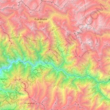
Name: Nichar topographic map, elevation, terrain.
Location: Nichar, Kinnaur, Himachal Pradesh, India (31.40405 77.74825 31.79360 78.18395)
Average elevation: 3,766 m
Minimum elevation: 1,188 m
Maximum elevation: 6,020 m
Other topographic maps
Click on a map to view its topography, its elevation and its terrain.
Nathpa Jhakri Dam
India > Himachal Pradesh > Kinnaur > Nichar
Nathpa Jhakri Dam, Nichar, Kinnaur, Himachal Pradesh, India
Average elevation: 1,958 m