
Kothamangalam topographic map
Interactive map
Click on the map to display elevation.
Kothamangalam
Kothamangalam is situated in the eastern part of the Ernakulam district. According to the division of the geographical regions of Kerala, Kothamangalam is in a mid-land region. The general topography is hilly.
About this map
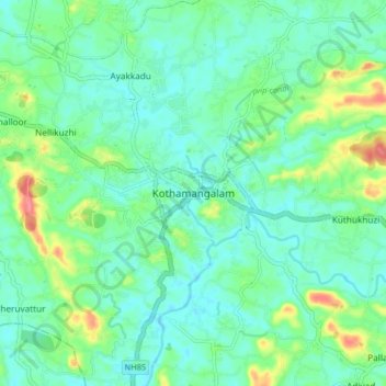
Name: Kothamangalam topographic map, elevation, terrain.
Location: Kothamangalam, Ernakulam, Kerala, 686666, India (10.02403 76.58182 10.10403 76.66182)
Average elevation: 34 m
Minimum elevation: 15 m
Maximum elevation: 90 m
Other topographic maps
Click on a map to view its topography, its elevation and its terrain.