
Thank you for supporting this site ❤️
Make a donation
Make a donation
Kothamangalam topographic map
Click on the map to display elevation.
Thank you for supporting this site ❤️
Make a donation
Make a donation
Kothamangalam
Kothamangalam is situated in the eastern part of the Ernakulam district. According to the division of the geographical regions of Kerala, Kothamangalam is in a mid-land region. The general topography is hilly.
Thank you for supporting this site ❤️
Make a donation
Make a donation
About this map
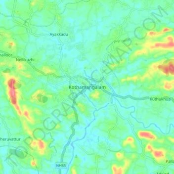
Name: Kothamangalam topographic map, elevation, terrain.
Location: Kothamangalam, Ernakulam, Kerala, 686666, India (10.02403 76.58182 10.10403 76.66182)
Average elevation: 34 m
Minimum elevation: 15 m
Maximum elevation: 90 m
Thank you for supporting this site ❤️
Make a donation
Make a donation
Other topographic maps
Click on a map to view its topography, its elevation and its terrain.