
Mangalagiri topographic map
Interactive map
Click on the map to display elevation.
About this map
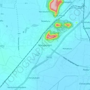
Name: Mangalagiri topographic map, elevation, terrain.
Location: Mangalagiri, Guntur, Andhra Pradesh, 522500, India (16.39182 80.52881 16.47182 80.60881)
Average elevation: 29 m
Minimum elevation: 15 m
Maximum elevation: 245 m
Mangalagiri is located at 16°26′N 80°33′E / 16.43°N 80.55°E / 16.43; 80.55. It has an average elevation of 29.08 m (95.4 ft).It is located 26 kilometres (16 mi) north east of the district headquarters, Guntur, and just 10 km (6.2 mi) south west of Vijayawada and also 30 km (19 mi) to the north west of Tenali by road. It lies on hilly terrain. It falls under Seismic Zone 3.
Other topographic maps
Click on a map to view its topography, its elevation and its terrain.
Kuragallu
India > Andhra Pradesh > Mangalagiri > Amaravati
Kuragallu, Amaravati, Mangalagiri, Guntur, Andhra Pradesh, 522500, India
Average elevation: 23 m