
Kotagiri topographic map
Interactive map
Click on the map to display elevation.
About this map
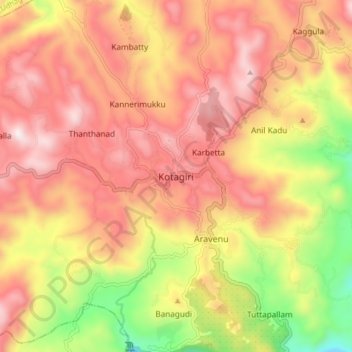
Name: Kotagiri topographic map, elevation, terrain.
Location: Kotagiri, The Nilgiris District, Tamil Nadu, 643217, India (11.38304 76.82582 11.46304 76.90582)
Average elevation: 1,781 m
Minimum elevation: 1,290 m
Maximum elevation: 2,125 m
Kotagiri is located at 11°26′N 76°53′E / 11.43°N 76.88°E / 11.43; 76.88. It has an average elevation of 1,847 m (6,060 ft).
Other topographic maps
Click on a map to view its topography, its elevation and its terrain.
Kattabettu
India > Tamil Nadu > Kotagiri
Kattabettu, Kotagiri, The Nilgiris District, Tamil Nadu, 643214, India
Average elevation: 1,988 m