
Thank you for supporting this site ❤️
Make a donation
Make a donation
Welimada topographic map
Click on the map to display elevation.
Thank you for supporting this site ❤️
Make a donation
Make a donation
About this map
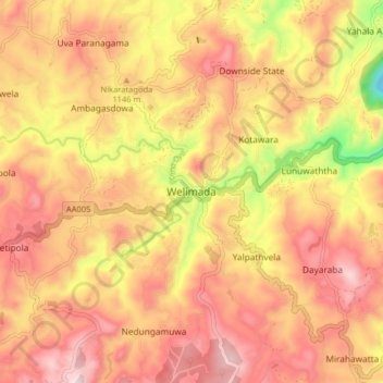
Name: Welimada topographic map, elevation, terrain.
Location: Welimada, Badulla District, Uva Province, 90200, Sri Lanka (6.86584 80.86981 6.94584 80.94981)
Average elevation: 1,127 m
Minimum elevation: 795 m
Maximum elevation: 1,332 m
Thank you for supporting this site ❤️
Make a donation
Make a donation
Other topographic maps
Click on a map to view its topography, its elevation and its terrain.