Geolocate

Kizhakkambalam topographic map

Interactive map

Click on the map to display elevation.

About this map

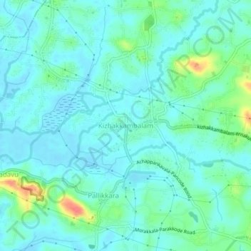
Name: Kizhakkambalam topographic map, elevation, terrain.

Location: Kizhakkambalam, Kunnathunad, Ernakulam, Kerala, 683562, India (10.01683 76.38694 10.05683 76.42694)

Average elevation: 12 m

Minimum elevation: -3 m

Maximum elevation: 58 m

Other topographic maps

Click on a map to view its topography, its elevation and its terrain.

Pettamala

India > Kerala > Kunnathunad

Average elevation: 23 m

Vadavukode

India > Kerala > Kunnathunad > Meempara

Average elevation: 21 m

Kadambrayar river

India > Kerala > Kunnathunad > Manakkakadavu

Average elevation: 9 m

Vengola

India > Kerala > Kunnathunad > Perumbavoor

Average elevation: 23 m

Rayamangalam

India > Kerala > Kunnathunad > Ambalampady

Average elevation: 31 m

Umma Chira, Pulluvazhi

India > Kerala > Kunnathunad > Pulluvazhi

Average elevation: 27 m