
Lukla topographic map
Interactive map
Click on the map to display elevation.
About this map
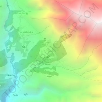
Name: Lukla topographic map, elevation, terrain.
Location: Lukla, Khumbupasanglahmu, Solukhumbu, Koshi Province, Nepal (27.66897 86.71067 27.70897 86.75067)
Average elevation: 2,996 m
Minimum elevation: 1,969 m
Maximum elevation: 4,436 m
Other topographic maps
Click on a map to view its topography, its elevation and its terrain.
Mount Everest
Nepal > Koshi Province > Solukhumbu
Mount Everest, Khumbupasanglahmu, Solukhumbu, Koshi Province, Nepal
Average elevation: 7,847 m
Phaplu
Nepal > Koshi Province > Solukhumbu
Phaplu, Solududhkunda, Solukhumbu, Koshi Province, 50600, Nepal
Average elevation: 2,518 m
Tingla
Nepal > Koshi Province > Solukhumbu
Tingla, Nechasalyan-06, Nechasalyan, Solukhumbu, Koshi Province, Nepal
Average elevation: 1,843 m
Himalayas
Nepal > Koshi Province > Solukhumbu
Himalayas, Khumbupasanglahmu, Solukhumbu, Koshi Province, Nepal
Average elevation: 7,555 m